By Gary Huff
Klahhane Ridge Peak: 6,046 ft. Elevation gain: 2,050 ft. Distance: 4.6 mi. Time: 3 hrs. Enjoyment rating: 4+ 100% alpine. Trailhead: 4,000 ft.
First Top Peak: 5,740 ft. Elevation gain: 2,800 ft. Distance: 8 mi. Time: 5 hrs. 100% alpine. Trailhead: 4,000 ft. Enjoyment rating: 4+

irst Top Peak, center. Second Top, right. Mt. Angeles, not shown, is the third top
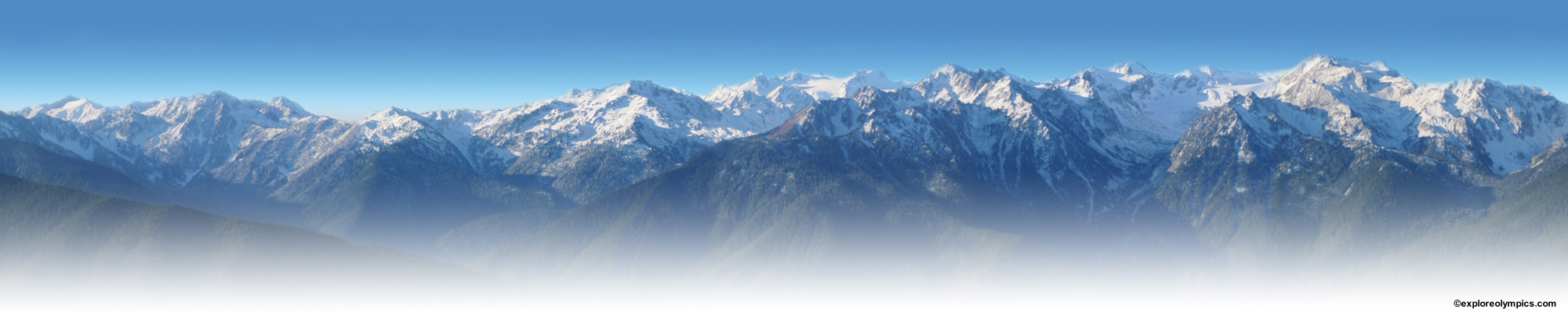
Overview:This beautiful alpine hike to either peak is an alternative to going up Mt. Angeles. Both peaks are on the same trail as Mt. Angeles. Klahhane Ridge Peak is one mile north of the Mt. Angeles saddle and First Top Peak is two miles west. Both are walk up peaks with great views of the Olympic Mountains, Vancouver Island and the Strait of Juan de Fuca. Wild flowers are prolific and mountain goats are often seen on these slopes. Both peaks are favorites of mine because they offer a quick but spectacular alpine experience.
Getting to the Trailhead:From Hwy 101 in Port Angeles turn south at the Olympic National Park sign on Race Street and continue past the National Park Visitor’s Center. From here it is 17 paved miles to the top of Hurricane Ridge. You enter the park at a toll both 5 miles up the road. Two miles before the top on the right is your trailhead, the signed switchback trailhead. Plenty of parking is available. (If you want to get to the trailhead at the Hurricane Ridge Visitor’s Center continue up the road two miles to the top and park at the beginning (east end) of the parking lot. The trail starts here.)
The Trail:The switchback trail begins at 4,000 ft. It is a fairly steep trail, gaining 1,850 ft to the 5,850 foot Angeles saddle in 1.6 miles. “Switchback” describes it well. (Note: If you want less steep and are willing to walk extra distance, start at the Hurricane Ridge Visitor’s center parking lot, elevation 5,250 ft. It will almost double the round trip distance to 8 miles but cut the elevation gain by 600 ft.) The 1.6 mi. trail up to the Angeles saddle switchbacks through open alpine meadows with spectacular views all the way up. Stunted alpine firs and basaltic rock outcroppings dot the landscape. Thousands of wild flowers; including spring beauty, paintbrush, lupine, glacier lily, sandwort, bistort, wallflower, bluebells and asters cover the meadows until mid summer. At the saddle you have the option of going up Mt. Angeles, turning left toward Heather Pass or turning right toward Klahhane Ridge and Lake Angeles.
The Peaks: ForKlahhane Ridge Peak, turn right at the saddle and climb gradually up for an additional mile, through pleasant alpine ridge meadows, to the peak at 6,046 ft. Views from here are spectacular in every direction. The Strait of Juan de Fuca and Vancouver Island dominate the north, Mt. Olympus and Mt. Carrie south. The Grand Ridge and Grand Valley peaks are east: Blue, Maiden, Elk, Obstruction, Eagle, Moosehead, Grand and McCartney. West are good views of First Top, Second Top, Hurricane Hill, & Unicorn. A close up look at Mt. Angeles, one mile away, is dramatic.
The trail continues on from here but begins dropping down more sharply, down to Lake Angeles and the Lake Angeles trailhead. If you would like a view down to Lake Angeles, 1,000 feet below, continue downhill for another half mile to a rocky overlook.
To get to First Top Peak, turn left at the Angeles saddle sign and hike a beautiful two miles over another saddle to Heather Pass and First Top Peak. The peak, at 5,740 ft., is a walk up and is just 200 feet west of Heather Pass. (Heather Park is a half mile farther down the trail.) Here is a description of the two mile trail, from Angeles saddle to First Top. From the Angeles saddle, the trail will drop down slightly, and then ascend steeply, through scree, to a saddle just east of Second Top, another Angeles Peak. This is mile one. The trail drops slightly again, until it passes by dramatic, Egg Rock on the left. Egg rock or the thumb, is a tall rock spire and a very difficult class V climb. The trail then climbs gradually through alpine firs to Heather Pass, 2 miles from Angeles Pass. Views are abundant and varied all along the trail and culminate at First Top peak, which is 200 feet west of Heather Pass. To the West you can see the mouth of the Strait of Juan de Fuca and about 40 miles of the Vancouver Island shoreline including Port Renfrew. To the North are Port Angeles, Victoria, Sequim and the Dungeness Spit, Mt Baker and the Cascades. To the South are Mt. Olympus and the peaks of the interior Olympics.
Another adventurous way to experience this area is to hike the entire Heather Park-Mt. Angeles-Lake Angeles loop beginning near the park entrance station at the Heather Park and Lake Angeles trailheads. Trailhead elevation is 1,950 feet. The loop, a difficult 13 miles, and 4,600 feet of elevation gain will take about 9 hrs but is worth the effort. It covers all the trails listed here plus you will see Heather Park and Lake Angeles.
The thumbnail images below can be viewed as a slide show, just click on an image to start slideshow. Click or tap on the right or left side of the image to view the next or previous image. Click or tap outside the slideshow image and the slideshow will close.
-

- First Top from Heather Pass trail

-

- irst Top Peak, center. Second Top, right. Mt. Angeles, not shown, is the third top


To “Pin” an image, click the “Pin It” button and select image from list.