Story and Photos by Bret Wirta – The Incidental Explorer
Distance: 45 miles Time out: 3 days
Degree of Difficulty: 2 Highest Elevation: 5,274 ft.
Pet Friendly: No

Skyline trail map by Sequim artist Per Berg
Since it was first proclaimed a forest preserve in 1897, federal protection of the Olympic Peninsula wilderness was wildly unpopular with those who made their living there, namely the loggers, miners, hunters, trappers and homesteaders. Could these interests succeed in repealing the legislation? Who would advocate for a backwoods so rugged that only a few explorers had ever journeyed through? Unbelievably, it was handful of wide-eyed professors and poets of the nascent Seattle Mountaineers climbing club who would first penetrate the Olympics in the name of outdoor recreation and help establish a new and sustainable industry – tourism. Join me as I hike along the Skyline Trail, one of the most difficult in Olympic National Park, and tell this story. – The Incidental Explorer
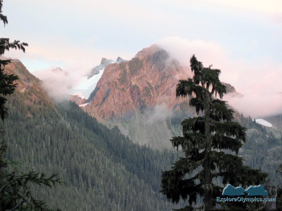
High along the spine of the Quinault and Queets River watersheds in the middle of Olympic National Park hides a little-used trail that is as spectacular as it is challenging – the Skyline Ridge Trail. “Not for the careful or timid,” said a 1928 U. S. Forest Service trail inspection report. Today its reputation has not changed. A wilderness photographer identified only as Barefoot Jake called the Skyline Ridge Trail “the most challenging primitive trail in the Park.” I planned to backpack the 45-mile trail by myself, following the footsteps of the remarkable pioneers of outdoor recreation who inaugurated the trail a century ago – the Seattle Mountaineers.

Skyline Ridge Trail
I slept that night in the back of my car at the North Fork Trailhead to ensure an early start. The next morning I popped awake, slipped on my backpack and was on the trail before 7, glancing uneasily at the dark, cloudy sky through the branches of the forest. The first segment of the Skyline Ridge Trail loop was the seven-mile-long Big Creek Trail, which began at 500 feet in elevation and wound through the boggy rain forest between moss-draped hardwood giants and thick underbrush.
It had been a pretty dry summer, but a big storm was forecast to hit the coast in a couple of days. I was hoping that I’d be down off the exposed ridge and back in the sheltered rainforest before it arrived.

Rain forest lowlands
The advent of tourism along the hiking trails of the Olympic Mountains can be traced to outings sponsored by organized climbing clubs of the early 1900s, especially the Seattle Mountaineers. The wilderness had been explored and mapped only 17 years earlier when the Seattle Mountaineers first strode jauntily into the Olympics. The Mountaineers’ original goal was a first ascent of Mount Olympus, but their much-publicized presence in wilderness would serve a bigger mission – namely saving the newly created Olympic National Monument.

UW Digital Collection Album 2913a Men and women on outing route August 1920
In 1897 President Grover Cleveland established the Olympic Forest Preserve. The loggers, miners, hunters and trappers, basically the only people roaming the Olympics at the time, shouted down the new rules. Preservation had few friends in Congress, either. Loopholes were quickly created for mining and logging. Besides, what else was the forest good for? There were no recreational hiking trails into the Olympics. Who else would even venture into the wilderness?
In 1907, the newly created outdoor club, the Seattle Mountaineers, announced that exploring the Olympic Peninsula wilderness and climbing Mount Olympus was the goal of its very first summer outing. The 65 hikers, mostly well-off urbanites, would need transportation, provisions and gear, plus the services of packers, hunters, guides, trail cooks and photographers. Knowing that this small army was headed their way, the Port Angeles business community was compelled to hack through 60 miles of forest and restore the old Seattle Press Expedition Trail up the Elwha River (more on that below). That bolus of Seattle Mountaineer cash must have made those struggling merchants giddy.

Man packing a horse, UW Digital Collection Album 27085a Seattle Mountaineers 2nd Olympic Outing, August 1913
Meanwhile, five miles from the trailhead, the boggy trail had turned rocky and the forest thinned. I slowed my pace and crossed a steel bridge that arched high above Big Creek. Far below, the tumbling stream had scoured the dark-gray shale to a glassy smoothness. Across the bridge, the trail began to gain altitude with every step. By mid-morning the ground had turned wet and spongy again as the trail wound through a stand of cedars. I rested at a carved wooden sign that read: “Record Alaska Cedar. Diameter 12 ft, Circumference 37’ 8 1/2”, Height 120 feet.” I ran my fingers across the forest patriarch’s rough silver bark and looked skyward in awe. I said a prayer of thanks that previous generations had the foresight to protect this tree and this beautiful park.

Record Alaska Cedar
Back in 1907, the Seattle Mountaineers’ three-week summer outing into the Olympics was a success. Though club historian Mary Banks complained that three rogue hikers tried to summit Olympus on the trail that the Mountaineers made possible, the rest of the outing’s plan was executed with precision. The Mountaineers were the first to climb the west peak of Mount Olympus, the true summit, and they explored the Elwha and Quinault River valleys. Mary Banks gushed that it was “probably the most wonderful outing ever taken by any mountain-climbing club.”
After their successful 1907 Olympic outing, the Seattle Mountaineers turned to other unexplored regions of the Northwest. With the hiking club gone, the resources of the Olympic Forest Preserve continued to be exploited, especially the magnificent Roosevelt Elk. The latter, in fact, were headed toward extinction. Trappers, miners and homesteaders hunted for subsistence, wealthy hunters for sport, while some hunted the elk just for their teeth. Elk are one of the only animals in North America that have ivory canines. Members of the Benevolent and Protective Order of Elks once sought out these teeth. A prized possession of Elks Club members was a jewel-encrusted, gold-mounted, elk tooth pendant.(Read more: In the Footsteps of the 1890 Banner Party: Backpacking the North Fork Skokomish River Trail)
President Theodore Roosevelt listened and took action in 1909, during the last days of his administration. Using the newly created Antiquities Act that was written for the protection of lands of historic and scientific interests, the president created Olympic National Monument. Mining, logging and especially hunting was banned. Thanks to Teddy Roosevelt, the indigenous elk species that now bears his name would not suffer the same fate as the North American Bison, which had been exterminated from the plains just a couple of decades earlier.
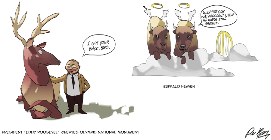
Roosevelt saves the Olympic Elk by Sequim Artist Per Berg
I rested at Camp Three Lakes. I had been hiking most of the day and hadn’t encountered a soul. Today the Skyline Ridge Trail is so little used that it’s no longer part of the maintained trail system of Olympic National Park. This was the problem for the newly created Olympic National Monument – few recreational users. Meanwhile, those actually living on the Olympic Peninsula in the early 1900s – the miners, lumbermen, trappers, hunters and homesteaders – cried out for exemptions and to reduce the size of the monument. Political leaders nodded in agreement. Why lock up all this land if nobody is using it?
Who would fight to save the Monument? The Seattle Mountaineers promised they would return to the Olympic Peninsula only if the U.S. Forest Service, the new administrators of the Olympic National Monument, would build them a different trail. At the time, the Forest Service placed little value on recreational usage, but with a surprisingly clear vision of the future, they agreed.
In the summer of 1913 the Olympics again rang out with the sounds of the Seattle Mountaineers’ thunderous march. For three weeks over 100 happy campers explored the valleys, climbed the mountains and canoed the rivers of the Olympic National Monument. As in 1907, they made their way up the Elwha River toward Mount Olympus. After climbing the peak and recording many other first ascents, they continued over Low Divide and headed down the Quinault River valley toward the sea.
This time the Mountaineers turned up Elip Creek Ridge onto the southern tip of the Skyline Ridge. Here the hikers arrived at the point where I sat at Camp Three Lakes. Hiker Gertrude Streator wrote: “August twentieth found the Mountaineers again on the new trail which was scarcely finished before we were passing over it. Those who helped construct the trail certainly deserve the highest praise, as it was through their efforts that the trip was possible.”

UW Digital Collection Album 27103a Mountaineers and horses in meadow August 1913
But just two years later, miners searching for an obscure mineral called manganese struck a stunning blow to the Olympic National Monument. Manganese is crucial in making hardened steel – important for warships – and virtually none was available domestically. Prior to World War I, when imports were threatened, the U.S. government was excited to find manganese lodes in the reddish colored limestone of the Olympics. Read more: In the Footsteps of Early Geologists: Searching for Clues to how the Olympics were Formed)
In 1915 President Woodrow Wilson cut the size of the monument almost in half to allow manganese prospecting. The timber industry perked up, because almost all of the reduced Monument was above the timberline. Stripped of protection, large-scale logging began in the untouched forests.

Red Hematite and Pyrolusite (manganese) from Crescent Mine
While half of the formerly protected Olympic National Monument was being mined and logged, the Seattle Mountaineers refused to return to the Olympics. In 1916 the Mountaineers huffed that their next Olympic outing would not be conducted until the high trail along the rest of the Skyline Ridge was finished. The U.S. Forest Service struggled to comply, but a shortage of men during World War I delayed the opening of this section of the Skyline Ridge Trail until the summer of 1920. Only then did the Seattle Mountaineers agree to return to the Olympic Peninsula.
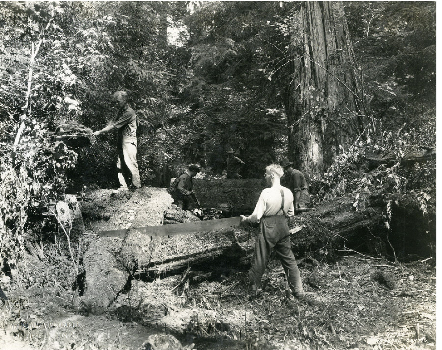
Forest Service building Quinault Trail circa 1920’s Courtesy Washington State Historical Society
I left Three Lakes and climbed on with just the breeze whispering through the trees to keep me company. Oh, to be a part of the camaraderie of the early Seattle Mountaineers summer outings in the Olympics! They marched along the trail, with the discipline of an army and the zeal to conquer the unconquered mountain peaks. The Mountaineers had everything they needed including their own clergy for Sunday morning service. The Reverend Hugh Elmer Brown was overjoyed to be out on the trail with the Mountaineers. He wrote that they had “…escaped completely from the over complicated life of the city where folks breathe second-hand oxygen and discuss books they have not read …”

Seattle Mountaineers at Kimta Creek Camp – 1920 – UW digital collection
At 3 p.m. and at 3,600 feet, my trail crossed a meadow at the headwaters of Three Prune Creek. The campsite was named by some hungry climbers when that’s all they had to eat at the end of the day because their packer didn’t arrive with supplies. I leaned back against a tree blackened from an old blaze and ate a snack (not prunes). Three Prunes Creek was my original destination for the night, but since the storm was lurking somewhere off the coast, I was eager to put some more miles behind me; so eager that I forgot to fill my water bottle, and that was a big mistake.
While I hiked alone and fretted about the pending storm, the Seattle Mountaineers were all about camaraderie and being positive. “The Mountaineers are the finest brand of sinners I have met for a long while. They seem mixed together in a rugged conspiracy to make things go happy,” said Reverend Hugh Elmer Brown.
Meanwhile I was not so happy. By 6 p.m. the trail had reached 5,000 feet and I was out of water. On the narrow, knife-edge of the Quinault-Queets watershed, trees were replaced with tufts of grass and marshy soil with rock and stone. The views were spectacular on either side, but there was no water to be found. Far below me to the west lay the Queets River valley while hundreds of feet below me to the east I could see the icy headwaters of Kimta Creek. I ate juicy blueberries along the trail for energy, but after gaining 4,500 feet in elevation it would take something more powerful than blueberries to give me the strength to climb down off that ridge for water.

Leaving trees behind
I’m sure the hyper-organized Seattle Mountaineers carried plenty of water when they crossed this same dry ridge during their 1920 summer outing. Just in time, once again, a new trail in the Quinault valley was ready for the Mountaineers. On August 16, 1920 Winona Bailey and the Mountaineers were hiking “… up Promise Creek on (an) excellent new trail completed by the Forest Service for this trip. Camp was made on site only a few days earlier by trail crew … ”
Meanwhile I was lurching along the rocky Skyline Ridge Trail with a dry mouth, while the tumbling waters of Promise Creek, far below, taunted me. I was still searching for water when around a bend lay a shallow, 10-foot wide puddle of snowmelt. I pumped the air with my fist! I boiled the heck out of that water and after dinner I boiled some more. I sat back and drank my fill of warm water, then ate soupy beef stew, fears of dehydration relieved.

Dinner and a warm bed
The temperature dropped rapidly at my camp at 5,000 feet. Cold fog and clouds reclaimed their familiar ground as they tumbled and roiled up the valley in front of me. The fiery rays of the setting sun shot up and silhouetted the ridge behind me. Perhaps the Reverend Hugh Elmer Brown was referring to a similar sight here on Skyline Ridge with the Mountaineers a century ago when he said, “Each summit brought its own unspeakable sense of detachment from lower things and its panorama of heart-piercing grandeur. Peaks became so many raised letters whereby blind children of the Most High were enabled to spell out something more of the divine message.”

Spectacular show
The next morning, I pulled the flap back on my tent and looked out at swirling mists and rain in the direction where I’d come from. I scampered outside and ran about shoving equipment into my backpack while all was still dry. My joints snapped, crackled and popped just like the breakfast cereal. I was rambling along the Skyline Ridge Trail before 7 a.m., without a cup of morning coffee, trying to stay ahead of the rain. Back in the summer of 1920, the Mountaineers experienced the same weather here on the ridge. “This was a day of mists, the day of fine views when nothing was seen,” Winona Bailey said.
While I carried all I needed on my back, The Seattle Mountaineers needed pack horses to haul their tons of equipment and supplies. The Mountaineers, most definitely, did not live off the land in the Olympics. According to historian Robert L. Woods, “Never had climbers had ‘better or more elaborate meals’ served to them by smiling cooks who could create, ‘delicious pies, cakes and other delicacies’… Using a small oven and bonfire, the cooks baked bread every day and served multi-course meals to from forty to seventy-five hungry climbers. Occasionally, the participants dined on fresh beefsteak which had been brought in ‘on the hoof’ by driving livestock up the trail and butchering the animals in camp.”
Day 2 and good morning
I’d planned on a quick climb up Kimta Peak, but failed to notice the path to the summit in the thick clouds and mist. I could see why Kimta Peak has been called the fog capital of the Olympics. A mile later along the ridge, the trail passed through an entire forest of dead gray tree trunks and scrubby underbrush called the Queets Burn. As I climbed the stony lip of Promise Creek Pass the mist lifted and I was suddenly surrounded by blue sky. It was rugged country; grasses, a few stunted trees and patches of heather were all that grew here.

Over Promise Creek Pass
The Seattle Mountaineer outings weren’t just culinary affairs; it was the evening entertainment that many recounted. There were ribald theatrical productions and music, but mostly it was club President Edmond Meany holding court around an enormous bonfire. Meany would tell local Native American legends, stories about early explorers or read his own poetry while the flames danced high into the night sky.
At Promise Creek Pass I said goodbye to the path of the Seattle Mountaineers 1920 outing and entered a region that Robert L. Woods called the wildest parts of the Olympics accessible by trail. And it was a hellacious trail, switching up and down and back and forth along the cliffs of the naked divide. I inched along a foot-wide ledge with no handholds and a 300-foot drop. I crossed shattered and confusing layers of rock that had been folded, flipped and turned on edge. There were tufts of anemic grasses and fists of heather, but for the most part there was no vegetation at all. One desolate ledge of sandstone looked like a petrified forest of stumps, trunks and hunks of bark that had exploded into chaos.
There was no visible path on the bald rock, but cairns marked the way. I didn’t leave sight of the pile of stones behind me until I could identify the pile of stones stacked somewhere on the trail in front of me. I imagined how murderous reconnoitering through here would be in fog or a driving rain.

Heated, folded, faulted and shattered
In the early afternoon I rested at an oasis of green that lived inside a narrow fissure in the rock. A tiny stream trickled and I filled my water bottle. Bright green moss and blue flowering Mountain Bog Gentian contrasted against the gray rock like a golf course fairway in a desert. I moved on. Shortly after, thin topsoil began to cover the naked rock, the cairns disappeared and an easily discernable path returned. The flowers and the greenery energized me, so I decided I’d hike a few more miles and camp at Lake Beauty. It was about then that the weather changed again; the wind increased, clouds engulfed the trail, and sheets of rain pelted me. The scenic vistas were obscured in a lashing downpour. I put my head down and trudged on.

Rain and fog move in
The cold rain beat down has I plodded on along the Skyline Trail toward Seattle Creek. Back in the 1920s the character of the Olympics was changing. The Seattle Mountaineers returned again in 1926, but this summer’s outing was different. No longer were the Mountaineers explorers of the uncharted wilderness. Mountaineers who didn’t see civilization for three weeks during past Olympic outings luxuriated in the warm sulfur baths at Olympic Hot Springs Resort midway into their excursion. Instead of a narrow trail up the Elwha, layered with blow-downs, the Mountaineers walked along a wide road past a noisy construction camp where a massive dam was being built.
Even their canoe trip down the Quinault River to the sea had changed. Professor Meany lamented, “In quiet stretches the spruce forests echoed with the ‘put-put’ of outboard motors, contrasting strangely with former outing memories of the steady dip, dip, dip, of paddles in the silent depths of green water.”

Mt Noyes, Seattle Creek and Mt Seattle
A few miserable hours later the rain ended and the sun burned through the clouds, warming my dripping body and thawing my mind. It was early evening and somewhere during that storm, with my head down, I had stumbled past the turnoff to Lake Beauty. At 3,800 feet in elevation I had crossed Seattle Creek, its beautiful waterfall barely registering. Now as I climbed the thousand-foot ridge on the other side of Seattle Creek the slanting sunshine dried my pruney fingers and the expansive views elevated my attitude.
Back in the 1920s, the shifting character of the Olympics changed the Mountaineers, too. Instead of pathfinders the Mountaineers were becoming outdoor recreation advocates. Their stories highlighting the wild beauty of the Olympics appeared in publications across the country. The Mountaineers no longer planned outings just so that they could be the first to ascend un-climbed peaks; they began to promote easier access into the Olympics.
There were even Mountaineers that advocated for a string of chalets throughout the Olympic wilderness. Frank H. Lamb said, “Strategically located at scenic vantage points, (the chalets) would tempt alike the novice and the more experienced climbers to scale the nearby peaks, to whip the close-by trout streams, to penetrate into many hidden mountain retreats.”

Late evening sun
I fought to keep walking until I found a campsite with a view, but by 7 p.m. I was so exhausted that I just threw down my backpack on a tiny level space right next to the wooded trail. As I was pitching my tent, fog began rolling up the valley. It had been warm and sunny just a few minutes before, but the temperature quickly turned cold in the mist.
Back in the 1920s new logging technology made the threat to the last of the Peninsula’s primeval forests acute and immediate. Denuding entire forests became much easier. No longer did horses or oxen and drivers take only the big timber and leave the rest to grow. With steam engines and cables dangling from the tops of solitary spar poles, logs were yanked along the ground like battering rams, gouging deep trenches into the earth. Meanwhile, mechanized saws allowed a single man to clear anything else left standing. Finally, the new generation of railroad engineers and bridge builders laid tracks for the iron horse, with its power to haul an unlimited number of colossal logs, deep into the Peninsula. Where beautiful forests once stood, now miles and miles of ugly stumps and dead limbs sat, waiting to spark into an inferno. Read more: In the Footsteps of Sawmills and Timber Beasts: Searching for the Snow Creek Logging Company)

Snow Creek Logging Company trestle and spar tree courtesy of the Clallam County Historical Society
Not only did advanced mechanization make clear-cutting forests easier, but as the 1920s ended local conservationists had lost almost every battle to preserve the Olympics. There was talk of creating a national park with the tiny amount of land left from the original monument, but even the idea of protected park, no matter how small, was blocked by the logging barons who controlled the economy of the region. The Seattle Chamber of Commerce published a report pushing for mining, dam building, road construction and especially logging in the proposed park. Naturalist Tim McNulty wrote, “By the late 1920’s, much of the forests removed from the original Olympic Forest Reserve were gone, and mill owners turned their gaze to the trees in the national forest. The forest service was happy to accommodate. A 1915 timber management plan for the forest announced the ‘chief function of the national forest is the furnishing a continuous supply of timber.’ Cutting levels on Olympic that year were around 12 million board feet. They shot up to 175 million by 1928. In its 1926 timber harvest plan, the forest service went so far as to include forests inside the national monument in its cutting circles.”

Business on the Olympic Peninsula circa 1920s by Sequim Artist Per Berg
Thankfully I had finished dinner and had already crawled into my sleeping bag when the storm I had been worried about hit. Hard rain lashed my tent. A Quileute legend says that storms on the Peninsula are caused when the monstrous raven that lives inside Mount Olympus takes flight. Its flapping wings make thunder and great winds. When it opens and shuts its eyes, lightning cracks. That raven must have flown over my tent for hours, for the tempest lasted most of the night.
By the 1930s the stormy debate had intensified and blown eastward all the way to Washington D.C. and New York City. Time was running out for the last of the old-growth forests of the Olympic Peninsula, but thankfully, the Seattle Mountaineers and their local allies were no longer battling the timber barons and their rich allies alone. The debate over the creation of a national park had fittingly become a nationwide battle. Just in time, too, because lumbermen were making plans to log the Hoh and Bogachiel River valleys, the last lowland stands of old growth timber left on the Peninsula.
The Seattle Mountaineers were joined by influential national leaders from organizations like the Izak Walton League, the Audubon Society and the American Museum of Natural History, along with politicians, newspaper editors and other conservation groups. But it wasn’t enough – the bill to create Olympic National Park died in the halls of the U.S. Congress in 1935.
Back on the Skyline Trail the wind and rain had stopped beating on my tent in the early morning. I unzipped the door and crawled out. I looked about and let out a big breath. The storm had lifted and I could see the Quinault Valley below me. I shook the water off my gear and was on the trail once again before 7 a.m.

Day 3 Good Morning above the Quinault River
It took the personal intervention of yet another U.S. president named Roosevelt to end the most contentious national park debate in our country. President Franklin D. Roosevelt visited the Olympic Peninsula in 1937. He and his motorcade arrived in Port Angeles during a soggy September rain. A banner read, “Mr. President, we children need your help. Give us our Olympic National Park.” According to newspaper reporter Alice Alexander, President Roosevelt responded, “Mr. Mayor and my friends of Port Angeles: That sign is the appealingest appeal I have ever seen in my travels. I am inclined to think it counts more to have the children want that park than all the rest of us put together. So, you boys and girls, I think you can count on my help in getting that national park, not only because we need it for us old people and you, young people, but for a whole lot of young people who are going to come along in the next hundred years of America.”
The President’s motorcade slowly circled the entire Peninsula where he met with officials, drove past devastating clear-cuts and viewed the precarious existence of the last of the primeval forests. The visit tipped the scales in the debate. Roosevelt wanted a national park and the opposition in Congress relented. President Franklin D. Roosevelt signed the bill creating Olympic National Park on June 29, 1938.

Roosevelt Parade in Port Angeles 1937, Courtesy Clallam County Historical Society
By a little after 8 a.m., I’d dropped down to 3,500 feet and I stood in a meadow at the junction of the North Fork Trail. The headwaters of the North Fork of the Quinault River gurgled through low bushes in front of me. Low Divide and the Elwha River watershed was in back of me. This was the end of the Skyline Trail. I had done it. I whooped and grinned. I wish I could have celebrated with the Mountaineers of old.
Conservationists continued to celebrate even after the Olympic National Park bill passed. A series of presidential actions added the old-growth forests of the Bogachiel River valley, the Queets Corridor, and the beaches along the seacoast, creating the Olympic National Park that we know and love today.

Junction of Skyline and North Fork Trails
I followed the Quinault River valley downstream. The wide North Fork Quinault Trail was like walking on a highway compared to the little-maintained Skyline Trail. This was the route through the Olympics that James Christie and his Press Expedition had shown the world in 1890 and which was now a broad path worn down by generations of backpackers, seeking their own adventures in the Olympic National Park.
But my worries weren’t over. Ahead of me was Sixteen Mile Ford. There was no bridge and there was no other place to walk across the bed of the river. If the river had become too swollen by the recent rains, I’d have to go back the way I came – an incomprehensible choice. (If you travel the Skyline Trail loop in a counter-clockwise direction you’d reach the ford at the beginning and not at the end of your trip – thus avoiding my dilemma.)
The worries over logging in Olympic National Park didn’t end after the park was created. During the great park debate the Mountaineers had been relatively silent compared to the powerful eastern conservation groups, but in the mid 1950s the Mountaineers found their voice once again. They exposed a loophole that allowed massive “salvage” logging operations inside Olympic National Park. The Seattle Mountaineers have remained an important leader in conservation and wilderness protection to this day.

Ford at Sixteen Mile
It was mid-morning when I easily forded river at Sixteen Mile, the water only reaching my knees. I spent the rest of the day walking and whistling down the North Fork trail. By early evening I was back down to 700 feet in the lower Quinault Valley forest. It felt like I was walking through a greenhouse where I could feel all the plants exhaling. It was hot and muggy compared to up on Skyline Ridge where the air was thin and clear.
When I paused for a snack, I felt a cool breeze beginning to cut through the humidity. The crowns of the soaring firs nodded in the wind. This park is so vast. I had been traveling for days and I just explored a tiny corner of its wilderness. I was small, but after completing the Skyline Trail I felt part of something much bigger. I smiled.
The Reverend Hugh Elmer Brown felt the same on the Mountaineers’ 1913 Olympic outing. Perhaps he was sitting in the same spot as me when he wrote: “The trees, like some old and mellow violin, brought us into many a tender and thoughtful mood. The benediction of insignificance fell upon us again and again as we listened to the murmurings of the forest giants which belong among the authentic antiquities of the world … and the elemental stillness of the woods here and there, when silence seemed be holding her breath, had for the soul a message all its own.”

The benediction of insignificance
I arrived back at my car at the trailhead at 6 p.m. It was the end of a successful journey over the difficult Skyline Trail. The Seattle Mountaineers’ early summer outings in the relatively unknown Olympic Peninsula were successful too. But why did that really matter?
The Seattle Mountaineers exposed the nascent U.S. Forest Service to the value of stewardship. The mountaineers showed that there was a use for the newly created National Monument that didn’t involve the extraction of natural resources. Instead of asking for permits for logging or mining, the Seattle Mountaineers asked for hiking trails. With easier access into the wilderness came more hikers. These early trails are still used today.
The debate over the creation and size of Olympic National Park was long and contentious. It required the weight of powerful leaders outside the Pacific Northwest to tip the scales in favor of creating a park where wilderness was the rule. It was the publications from those early Seattle Mountaineer outings that first showed the rest of the country the magnificence of the interior of the Olympic Peninsula. The Seattle Mountaineers successfully spread the word. This early desire to communicate led the Seattle Mountaineers to develop their own book division that today has published over 1,000 titles.
The Seattle Mountaineers continued their summer outings for over 80 years. Their early outings help pioneer an entirely new sector of our economy, the outdoor recreation industry. This created a powerful monetary incentive for conservation over extraction in our wild spaces. Today the economic contribution from the outdoor recreation industry is much greater than that of the timber industry in our state. According to the website Outdoor Industry, the outdoor recreation economy in Washington State alone supported 226,600 direct jobs and generated $7.1 billion in wages in 2012. According to the Washington Forest Protection Association’s 2015 Annual Report, the timber industry created 104,000 direct and forest-related jobs that pay wages of $4.9 billion.
The publicity from those early Seattle Mountaineer summer outings helped the Mountaineers grow into one of the most successful hiking and climbing clubs anywhere. The handful of charter members from that first summer outing in the Olympics has grown to over 10,000 active members today. Along the way the Seattle Mountaineers pioneered climbing, backcountry skiing and outdoor safety techniques, making spending time in the outdoors today safer and more enjoyable.
Before I backed my car out of the trailhead parking lot, I thought about my solo journey on the Skyline Trail. Exhausting, yet rewarding, the adventure would have been nice to share with fellow hikers, like a Seattle Mountaineer summer outing. I had the option to hike alone, but Danny Miller, then secretary of the Seattle Mountaineer History Committee, reminded me that, “It was such an ordeal to travel back then that these large group outings were the only practical way for most people to have a chance to experience something like that.”
Exploring the Olympics and the Skyline Ridge in a large group might have been a necessity on early Mountaineer outings, but the Reverend Hugh Elmer Brown didn’t want to travel any other way. About his summer in the Olympics with the Seattle Mountaineers back in 1913, Brown concluded, “Best of all and above all, I found new friends, who gave sparkle and zest to living. Richer than all the gifts of the mountain, stream and wood is the priceless benefaction of a trail-born comradeship.”
Next time I hike the Skyline Trail I’m going to bring along a friend or two.

End of the journey
I enjoyed researching this story and I would like to thank my sources. Olympic Peninsula Historian Rod Farlee explained the construction timeline of the Skyline Trail to me. The history of the Seattle Mountaineers was from The Mountaineers: A History, by Jim Kjeldsen (1998, the Mountaineers). Recollections of the Seattle Mountaineers’ early summer outings are from The Land that Slept Late: The Olympic Mountains in Legend and History by Robert L. Wood (1995, The Mountaineers). History of the battle over Olympic National Park was from Olympic National Park – A Natural History by Tim McNulty (2009, University of Washington Press). The recollection of FDR’s visit to Port Angeles was from a newspaper article titled, “A day that will live in Peninsula history: FDR came to visit,” by Alice Alexander (The Peninsula Daily News, Sept 12, 2009).
Barefoot Jake Morrison is an Olympic National Park enthusiastic adventure blogger who focuses on wilderness photography and a minimalist lifestyle. More at http://www.barefootjake.com.
I especially appreciated the following original source material from the Seattle Mountaineers’ own publication – The Mountaineer. The Edmond Meany quote was from the article “1926 Summer Outing in the Olympics” by Edmond S. Meany (Vol. 19, No. 1, December 1926). The quote from Frank Lamb was from “Making the Olympics Accessible” by Frank H. Lamb (Vol. 19, No. 1, 1926). The quotes from Reverend Brown were from the article “Melodious Days,” by Hugh Elmer Brown (Vol. 6, 1913). The quote from Seattle Mountaineer historian Mary Banks was from “Mountaineers in the Olympics” (Vol. 1, No. 3, September 1907).
The photos on the Skyline Trail are my own while the historical photos are used with permission from the UW Digital Collection, the Clallam County Historical Society and the Washington State Historical Society.
The statistics on the relative size of the outdoor recreation industry is from the Outdoor Industry website and the size of the timber industry is from the Washington Forest Protection Association website.
The original art and maps were drawn by my friend, Sequim artist Per Berg.
Any errors and omissions are my own.
The thumbnail images below can be viewed as a slide show, just click on an image to start slideshow. Click or tap on the right or left side of the image to view the next or previous image. Click or tap outside the slideshow image and the slideshow will close.
-

- Skyline trail map by Sequim artist Per Berg

-

- Skyline Ridge Trail

-

- Rain forest lowlands

-

- UW Digital Collection Album 2913a Men and women on outing route August 1920

-

- Man packing a horse, UW Digital Collection Album 27085a Seattle Mountaineers 2nd Olympic Outing, August 1913

-

- Record Alaska Cedar

-

- Roosevelt saves the Olympic Elk by Sequim Artist Per Berg

-

- UW Digital Collection Album 27103a Mountaineers and horses in meadow August 1913

-

- Red Hematite and Pyrolusite (manganese) from Crescent Mine

-

- Forest Service building Quinault Trail circa 1920’s Courtesy Washington State Historical Society

-

- Seattle Mountaineers at Kimta Creek Camp – 1920 – UW digital collection

-

- Leaving trees behind

-

- Dinner and a warm bed

-

- Spectacular show

-

- Day 2 and good morning

-

- Over Promise Creek Pass

-

- Heated, folded, faulted and shattered

-

- Rain and fog move in

-

- Mt Noyes, Seattle Creek and Mt Seattle

-

- Late evening sun

-

- Snow Creek Logging Company trestle and spar tree courtesy of the Clallam County Historical Society

-

- Business on the Olympic Peninsula circa 1920s by Sequim Artist Per Berg

-

- Day 3 Good Morning above the Quinault River

-

- Roosevelt Parade in Port Angeles 1937, Courtesy Clallam County Historical Society

-

- Junction of Skyline and North Fork Trails

-

- Ford at Sixteen Mile

-

- The benediction of insignificance

-

- End of the journey

To “Pin” an image, click the “Pin It” button and select image from list.


